
MIAMI — As the 2026 Atlantic hurricane season approaches, forecasters are closely watching what could become one of the most important climate drivers of the year: the development of a potentially strong El Niño. While early projections suggest the season may be less active than recent years, experts are warning that the influence of El Niño introduces a complicated and, in some ways, more dangerous forecast—one where fewer storms could still bring significant impacts to the United States.
Recent forecasts, including a widely cited outlook from AccuWeather, project between 11 and 16 named storms, with four to seven hurricanes and two to four major hurricanes expected during the 2026 season. Those numbers place the season near or slightly below historical averages, but meteorologists caution that averages can be misleading when evaluating risk.
The Atlantic hurricane season, which officially runs from June 1 through November 30, is shaped each year by a complex interaction of ocean temperatures, atmospheric conditions, and large-scale climate patterns. In 2026, the dominant factor is expected to be the transition away from La Niña conditions toward a developing El Niño, a shift that has historically had a significant influence on hurricane formation.
El Niño’s Dual Role: Suppressing Storms, Increasing Uncertainty
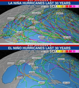
At its core, El Niño is characterized by warmer-than-average sea surface temperatures in the central and eastern Pacific Ocean. While this warming occurs thousands of miles from the Atlantic basin, its effects ripple across global weather systems, altering atmospheric circulation patterns in ways that can directly affect hurricane development.
One of the most important mechanisms is wind shear, or the change in wind speed and direction with height in the atmosphere. During El Niño years, stronger upper-level winds over the Atlantic tend to disrupt the structure of developing tropical systems, making it harder for storms to organize and intensify.
“Think of it as a hostile environment for storms,” one meteorologist explained in recent coverage. “Even if the ocean is warm, the atmosphere can essentially tear storms apart before they fully develop.”
This is why El Niño years are typically associated with fewer hurricanes in the Atlantic, and why the 2026 season is being forecast as near or slightly below average despite unusually warm ocean waters.
However, that same dynamic introduces a key layer of uncertainty. The strength and timing of El Niño will be critical. Forecast models suggest the pattern may not fully strengthen until later in the summer or early fall—meaning the early part of the hurricane season could behave very differently from the peak months.
Recent climate outlooks indicate there is a strong probability—around 60%—that El Niño conditions will develop by mid-2026, with some models even raising the possibility of a stronger event later in the year.
That timing matters. The Atlantic hurricane season typically peaks in August through October, and if El Niño strengthens late, it could suppress storm activity during the peak while allowing early-season development to occur under more favorable conditions.
Warm Waters Offset El Niño’s Suppression
Adding complexity to the forecast is the presence of exceptionally warm ocean temperatures across the Atlantic basin, a trend that has persisted in recent years and is closely tied to broader climate change patterns.
AccuWeather forecasters have warned that these warm waters could allow storms to form earlier than usual and intensify more rapidly once they do develop.
This creates what meteorologists describe as a “mixed signal” environment. On one hand, El Niño may limit the total number of storms. On the other hand, the storms that do form could become stronger more quickly, particularly if they develop in regions where wind shear is temporarily weaker.
This phenomenon—known as rapid intensification—has become an increasing concern in recent hurricane seasons. It refers to storms that strengthen dramatically in a short period, sometimes just hours before landfall, leaving little time for preparation or evacuation.
Forecasters emphasize that even in quieter seasons, the risk of a single high-impact storm remains significant.
“It only takes one,” AccuWeather experts have repeatedly stressed, referencing past seasons like 1992, when a relatively quiet year produced Hurricane Andrew, one of the most destructive storms in U.S. history.
Geographic Risk: Gulf Coast and Southeast in Focus
While hurricane forecasts focus heavily on storm counts, the more important question for residents is often where storms are likely to make landfall.
For 2026, forecasters are highlighting the northern and northeastern Gulf Coast and the Carolinas as areas with elevated risk of direct impacts.
This does not mean other regions are safe. Hurricanes can and do strike anywhere along the Atlantic coastline, from Texas to Maine. However, prevailing weather patterns and ocean conditions suggest that these regions may be more likely to see storm tracks during the upcoming season.
El Niño can also influence where storms form. During El Niño years, tropical systems are sometimes more likely to develop farther out in the Atlantic rather than close to the U.S. coastline. This can provide more time for forecasting and tracking, but it also allows storms to gather strength over open water.
A Season of Contrasts
The 2026 hurricane outlook reflects a broader theme seen increasingly in climate science: fewer storms does not necessarily mean less risk.
Recent news coverage highlights this contrast clearly. Forecasts call for a “near-normal but still potentially dangerous” season, with the possibility of multiple U.S. impacts despite a lower overall storm count.
This paradox is rooted in the evolving nature of hurricane behavior. Warmer ocean temperatures provide more energy for storms, while atmospheric conditions like wind shear determine how often storms can take advantage of that energy.
In years when those factors are in tension—as they are expected to be in 2026—the result can be a season with fewer storms overall but higher variability in intensity and impact.
The “Super El Niño” Wildcard
One of the most closely watched variables this year is the possibility of a stronger-than-normal El Niño, sometimes referred to as a “super El Niño.”
Such events are rare but can have profound global effects. Historically, strong El Niño years have been associated with significantly reduced Atlantic hurricane activity, but also with extreme weather patterns elsewhere, including increased rainfall in some regions and severe drought in others.
Recent projections suggest there is a smaller but notable chance that El Niño could intensify later in 2026, though forecasters caution that predictions at this stage remain uncertain due to what is known as the “spring prediction barrier”—a period when forecasting accuracy is lower.
If a strong El Niño does develop, it could further suppress Atlantic hurricane activity in the latter half of the season. However, it could also amplify the early-season risks and contribute to extreme weather patterns beyond hurricanes.
Preparedness Remains Critical
Despite the potential for a less active season, emergency management officials and meteorologists are emphasizing the importance of preparedness.
Recent guidance urges residents in hurricane-prone areas to review evacuation plans, update emergency supplies, and ensure insurance coverage is current.
The message is consistent across agencies and forecasters: do not let a “below-average” forecast create a false sense of security.
In fact, quieter seasons can sometimes catch communities off guard, particularly if early-season storms develop quickly or if a single storm produces significant impacts.
Looking Ahead
As the 2026 Atlantic hurricane season approaches, the interplay between El Niño and unusually warm Atlantic waters will remain the central storyline.
If El Niño strengthens as expected, it could act as a brake on overall storm activity. But if its development is delayed or weaker than forecast, the Atlantic could remain more favorable for storms longer than anticipated.
At the same time, the underlying trend of warmer ocean temperatures means that any storm that does form has the potential to intensify rapidly and cause significant damage.
For meteorologists, the season represents a complex forecasting challenge. For residents along the Atlantic and Gulf coasts, it represents a familiar but evolving threat—one shaped by both natural climate cycles and longer-term changes in the Earth’s climate system.
The bottom line is clear: the 2026 hurricane season may not be the busiest on record, but it has all the ingredients to be impactful. And as history has shown, it only takes one storm to define a season.